Lake Titicaca is the world’s highest lake navigable to large vessels, lying at 12,500 feet (3,810 m) above sea level in the Andes Mountains of South America, astride the border between Peru to the west and Bolivia to the east. Titicaca Lake is the second largest lake of South America (after Maracaibo).
It covers some 3,200 square miles (8,300 square km) and extends in a northwest-to-southeast direction for a distance of 120 miles (190 km). It is 50 miles (80 km) across at its widest point. A narrow strait, Tiquina, separates the lake into two bodies of water.

The smaller than Lake Titicaca, in the southeast, is called Lake Huinaymarca in Bolivia and Lake Pequeno in Peru; the larger, in the northwest, is called Lake Chucuito in Bolivia and Lake Grande in Peru.
The meaning of the name Titicaca is uncertain, but it has been variously translated as Rock of the Puma or Crag of Lead. Lake Titicaca lies between Andean ranges in a vast basin (about 22,400 square miles [58,000 square km] in area) that comprises most of the Altiplano (High Plateau) of the northern Andes. In the snow-covered Cordillera Real on the northeastern (Bolivian) shore of the lake, some of the highest peaks in the Andes rise to heights of more than 21,000 feet (6,400 m).
The lake averages between 460 and 600 feet (140 and 180 m) in depth, but the bottom tilts sharply toward the Bolivian shore, reaching its greatest recorded depth of 920 feet (280 m) off Isla Soto in the lake’s northeast corner.
More than 25 rivers empty their waters into Lake Titicaca; the largest, the Ramis, draining about two-fifths of the entire Titicaca Basin, enters the northwestern corner of the lake. One small river, the Desaguadero, drains the lake at its southern end. This single outlet empties only 5 percent of the lake’s excess water; the rest is lost by evaporation under the fierce sun and strong winds of the dry Altiplano.
Titicaca’s level fluctuates seasonally and over a cycle of years. During the rainy season (summer, from December to March) the level of the lake rises, normally to recede during the dry winter months. It was formerly believed that Titicaca was slowly drying up, but modern studies have seemed to refute this, indicating a more or less regular cycle of rise and fall.
Titicaca’s waters are limpid and only slightly brackish, with salinity ranging from 5.2 to 5.5 parts per 1,000. Surface temperatures average 56║ F (14║ C); from a thermocline at 66 feet (20 m) temperatures drop to 52║ F (11║ C) at the bottom. Analyses show measurable quantities of sodium chloride, sodium sulfate, calcium sulfate, and magnesium sulfate in the water.
Titicaca (Stone Puma) has lived a long life of millions of years. It contains the sum of all the ages that have moulded and defined the works that humans have undertaken in the southern Americas. Over this span of time, that reaches back some two million years, its body of water has been much larger, and encompassed areas today covered in salt flats and wasteland.
Lake Titicaca’s fish life consists principally of two species of killifish (Orestias)–a small fish, usually striped or barred with black–and a catfish (Trichomycterus). In 1939, and subsequently, trout were introduced into Titicaca. A large frog (Telmatobius), which may reach a length of nearly a foot, inhabits the shallower regions of the lake.
Forty-one islands, some of them densely populated, rise from Titicaca’s waters. The largest, Titicaca Island (Spanish: Isla de Titicaca, also called Isla del Sol), lies just off the tip of the Copacabana Peninsula in Bolivia.
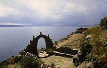
Ruins on the shore and on the islands attest to the previous existence of one of the oldest civilizations known in the Americas, antedating the Christian era. The chief site is at Tiahuanaco, Bolivia, at the southern end of the lake. On Titicaca Island ruins of a temple mark the spot where, according to the tradition of the Incas (a Quechuan people of Peru who established an empire about 1100), the legendary founders of the Inca dynasty, Manco Capac and Mama Ocllo, were sent down to Earth by the Sun.
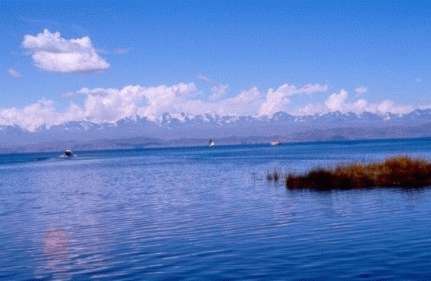
In Inca mythology, Manco Capac and Mama 0cllo, children of the Sun, emerged from the depths of Lake Titicaca to found their empire. Like famous naturalist Jacques Cousteau, today’s visitors to Titicaca will surely feel the same emotion that captivated the symbolic universe of the ancient Peruvians. With lofty snow-capped peaks along its far shores, the vast blue lake at 3,800m is one of the Andes’ most enchanting scenes.
This is an indigenous community of some 350 families which continues to live within the traditions of the 14th century, according to the principles of Inca life. Here, without noting the passing of time, the three golden rules of the Empire of the Sun have been kept: Ama suwa, Ama quella, Ama llulla (do not steal, don’t be idle, and do not lie). The contact with other civilizations has not been able to destroy the profound identity of the Inca way.
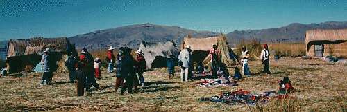
The Aymara people living in the Titicaca Basin still practice their ancient methods of agriculture on stepped terraces that predate Inca times. They grow barley, quinoa (a type of pigweed that produces a small grain), and the potato, which originated on the Altiplano. The highest cultivated plot in the world was found near Titicaca–a field of barley growing at a height of 15,420 feet (4,700 m) above sea level. At this height the grain never ripens, but the stalks furnish forage for llamas and alpacas, the American relatives of the camel that serve the Indians as beasts of burden and as a source of meat.
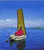
The remnants of an ancient people, the Uru, still live on floating mats of dried totora (a reedlike papyrus that grows in dense brakes in the marshy shallows). From the totora, the Uru and other lake dwellers make their famed balsas–boats fashioned of bundles of dried reeds lashed together that resemble the crescent-shaped papyrus craft pictured on ancient Egyptian monuments.
In 1862 the first steamer to ply the lake was prefabricated in England and carried in pieces on muleback up to the lake. Today vessels make regular crossings from Puno, on the Peruvian shore, to the small Bolivian port of Guaqui. A narrow-gauge railway connects Guaqui with La Paz, capital of Bolivia. The world’s second-highest railway runs from Puno down to Arequipa and the Pacific, completing for land-bound Bolivia, an important link with the sea.
Lake Titicaca and the House of the Golden Sun Disc
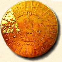
By Joshua and Vera Shapiro
Peru is a land steeped in ancient prophecies and wisdom that is vital for our planet during these transitional times.